MGEO005 Geowissenschaftliche Vertiefung I - Multiview Photogrammetry: 3D Virtual Geology for everyone
Compact course; next date in 2026
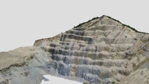
3D model of the Burgwenden quarry made from drone imagery.
Picture: Christoph Grützner3D photogrammetry is a rapidly developing field. The method allows a virtualization of geological outcrops for teaching and research. It forms the basis for 3D printing and countless applications.
This compact course will hopefully again be taught in spring 2026 by Prof. Marko VrabecExternal link (Uni Ljubljana).
Type: V/Ü, 2 SWS, 3 ECTS
Exam: Your own 3D-Modell
Instructor: Prof. Dr Marko Vrabec, Uni Ljubljana
Language: English
Schedule: 09:00-17:00, PC-Pool Burgweg 11; might switch to online if necessary
Who should take this course?
Anyone interested in 3D models, drones, virtual outcrops, high-resolution elevation models, digital geology.
Content:
1) Intro to SfM photogrammetry, with a practical hands-on example done by participants
2) Image acquisition and model georeferencing
3) Practical data acquisition in the field
4) Data processing and model creation
5) Finalizing the models and some advanced topics.
Aims: Students will learn to use photogrammetry and to make their own 3d models of any targets (outcrops, surfaces, hand specimens, buildings etc.).
Please register in Friedolin and drop me an email to help us planning: